top of page


What we offer
24/7 Emergency Search & Rescue
- Construction
- Agriculture and Forestry
- Inspection
- Thermal imaging
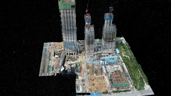
- AEC and Surveying
- Topographic mapping 2D & 3D
- Energy and Infrastructure
- Photography * Videography
- Search & rescue
- Real Estate
- FPV footage
- Drone training Academy & certification
- Topographic Mapping
- AEC and Surveying
- Emergency Response
- Law Enforcement
- Energy and Infrastructure
- Agriculture and Forestry Management

Real Time Kinematic (RTK)/Real Time Network (RTN) Global Navigation Satellite System (GNSS)
Compared to LiDAR, photogrammetry systems may struggle to pick out very small and finely detailed objects — for instance, while LiDAR pulses can pick up power lines, the photos taken by photogrammetry modules might not detect the wires. LiDAR is also able to penetrate through vegetation to capture the shape of the underlying terrain, and it can even work in the dark.
Multispectral and Agras spreader / sprayer drones with RTK correction
What is the role of Multispectral drone? Do I need it?
The function of RTK-enabled Multispectral is to quickly obtain accurate and precise multi-spectral data of crops, generate an expanded prescription map, which can help you judge the growth of crops and provide a more accurate data reference for crop management.


Thermal Imaging
No matter how much of a professional you are, human error is inevitable — it happens to the best of us! Using proper surveying techniques, a drone can create accurately scaled images and keep results consistent across an entire project. This is especially true if you’re working with a drone that can automate flight paths (, as this takes yet another potential area of human error out of the equation.


Inspection - High resolution images


FPV Drone Services (BVLOS)
If you're looking to elevate your FPV experience and need something faster, stronger, with more stamina than the common drone, you've come to the right place.
With more than 25 different FPV drones in our arsenal, we're able to accommodate a diverse range of requests.
We now offer drone training school for your basic or advanced pilot certificate with Transport Canada.
Are you ready for your in-person flight review?
Contact us to book your appointment!


bottom of page