top of page
Sky West Flights the leader of the drone services on the west cost - Agriculture - Inspection - Construction - Search and rescue - Forestry - Topographic mapping 2d & 3D - Agras drone spreader - Lidar drone - thermal drone - Photography - videography - Energy - wind turbine - power lines - RTK - DJI - skywestflights.com - skywestflights@gmail.com - Canada - Alberta - Calgary - Saskatchewan - British columbia - montreal - Quebec - drone survey - Drone Services Canada - dji matrice 300- m300 lidar - dji t10 - dji t40 - dji t30 - Kelowna - Canmore - Banff

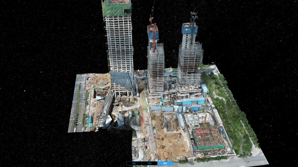
Topographic Surveying

Generate 1:500 scale maps without using GCPs while meeting centimeter-level accuracy requirements.

Improve the efficiency of data collection and processing up to 10 times, acquiring deliverables quickly and shortening project lifecycles.

Gain industry-standard outputs like DOM, DSM, 3D reality models and more.

Small teams can cover large areas quickly by operating multiple drones with a single remote controller.
Drone inspection for electricity

On the other hand, powerline drone inspection has become one of the fastest-growing applications under increased pressure to abide legal requirements and safety standards. Constant exposure to the elements can contribute to corrosion, calling for frequent drone inspections to facilitate early detection and damage assessment.

Sky West Flights the leader of the drone services on the west cost - Agriculture - Inspection - Construction - Search and rescue - Forestry - Topographic mapping 2d & 3D - Agras drone spreader - Lidar drone - thermal drone - Photography - videography - Energy - wind turbine - power lines - RTK - DJI - skywestflights.com - skywestflights@gmail.com - Canada - Alberta - Calgary - Saskatchewan - British columbia - montreal - Quebec - drone survey - Drone Services Canada - dji matrice 300- m300 lidar - dji t10 - dji t40 - dji t30 - Kelowna - Canmore - Banff
Drone inspection for agriculture
The integration of multispectral drones provides farmers high-quality data to help them identify healthy and distressed crops, and allows for precise intervention. Drones can also survey a crop periodically helping agronomists identify better crop management opportunities. Customized drone inspections can be performed with drones of the calibre of M3 Multispectral to facilitate precision agriculture activities such as contour mapping, livestock management, crop assessment, and insurance and yield estimate.
Drone inspection for chemicals, oil, and gas
When it comes to safety, the oil and gas industry is possibly the sector that benefits more from drone inspections. In a recent case study, a refinery and chemical plant spanning 2,300 acres – represents a highly hostile environment for humans, containing crude oil distilling units, catalytic crackers, and other operations for the production of hydrocarbons. With medical teams on-site to assist workers, drones have taken on the daunting task of inspecting such units, alleviating health concerns, and cutting unreasonable costs.
Sky West Flights the leader of the drone services on the west cost - Agriculture - Inspection - Construction - Search and rescue - Forestry - Topographic mapping 2d & 3D - Agras drone spreader - Lidar drone - thermal drone - Photography - videography - Energy - wind turbine - power lines - RTK - DJI - skywestflights.com - skywestflights@gmail.com - Canada - Alberta - Calgary - Saskatchewan - British columbia - montreal - Quebec - drone survey - Drone Services Canada - dji matrice 300- m300 lidar - dji t10 - dji t40 - dji t30 - Kelowna - Canmore - Banff
Roof inspection
No matter how much of a professional you are, human error is inevitable — it happens to the best of us! Using proper surveying techniques, a drone can create accurately scaled images and keep results consistent across an entire project. This is especially true if you’re working with a drone that can automate flight paths (more on that later), as this takes yet another potential area of human error out of the equation.
Wind turbine
Hail, snow, lightning, rain, salt, and dust are just some of the things that wind turbine components are forced to endure on a daily basis. In addition to this environmental stress, a turbine blade may also get damaged due to factors like extreme load buckling or manufacturing defects leading to debonding.
Sky West Flights the leader of the drone services on the west cost - Agriculture - Inspection - Construction - Search and rescue - Forestry - Topographic mapping 2d & 3D - Agras drone spreader - Lidar drone - thermal drone - Photography - videography - Energy - wind turbine - power lines - RTK - DJI - skywestflights.com - skywestflights@gmail.com - Canada - Alberta - Calgary - Saskatchewan - British columbia - montreal - Quebec - drone survey - Drone Services Canada - dji matrice 300- m300 lidar - dji t10 - dji t40 - dji t30 - Kelowna - Canmore - Banff
Solar panels
As humanity steps slowly back from the brink and its reliance on fossil fuels wanes, solar energy is taking center stage in the clean energy revolution. In the past 10 years, global installed solar energy capacity has increased a staggering 1,454% - from just 40 gigawatts (GW) in 2010 to an estimated 583.5 GW in 2020. By 2024, this is predicted to rise to more than 1,400 GW worldwide. 
bottom of page